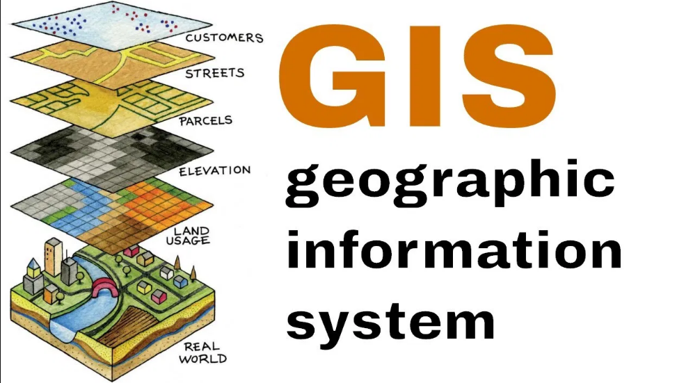
Geographic Information Systems
Geographic Information Systems (GIS) is a powerful tool used in civil engineering to capture, store, manipulate, analyze, manage, and present spatial or geographic data. GIS allows civil engineers to make better decisions by understanding the spatial relationships of various factors that affect infrastructure planning, design, construction, and maintenance. The integration of GIS with other civil engineering technologies has significantly enhanced the efficiency and precision of civil engineering projects.
Key Applications of GIS in Civil Engineering
- Urban Planning and Development:
- Zoning and Land Use: GIS is used to analyze land use patterns, zoning regulations, and urban sprawl. By overlaying different layers of data (e.g., population density, transportation infrastructure), planners can optimize land use and make informed decisions about where new developments should be located.
- Infrastructure Planning: GIS helps in planning utilities (water, electricity, sewage) by mapping existing infrastructure, identifying gaps, and proposing new systems.
- Transportation Engineering:
- Road Networks: GIS is used to design and manage road networks by analyzing existing infrastructure, traffic patterns, and geographic features. It helps in optimizing road layouts, assessing traffic flow, and proposing new road links.
- Route Optimization: GIS tools like network analysis are used for optimizing transportation routes, whether for logistics, public transport, or emergency services.
- Traffic Management: GIS assists in managing and modeling traffic flow to alleviate congestion by integrating traffic data with geographic maps.
- Environmental Impact Assessment (EIA):
- Flood Risk Mapping: GIS is crucial for mapping flood-prone areas by combining historical data, weather patterns, topography, and hydrology. It helps in flood management, planning, and designing flood mitigation measures.
- Climate and Environmental Monitoring: GIS is used to monitor environmental factors like soil erosion, vegetation cover, and changes in land use over time, allowing civil engineers to make environmentally sustainable design choices.
- Waste Management: GIS aids in the location and planning of waste disposal and treatment facilities, ensuring they are placed in areas that are efficient, safe, and compliant with regulations.
- Water Resources Management:
- Hydrological Modeling: GIS is used to model watershed areas, rainfall patterns, and river systems for better water resource management and flood forecasting. This helps in designing effective drainage systems, water reservoirs, and irrigation systems.
- Groundwater Analysis: GIS tools allow for mapping groundwater levels, pollution sources, and recharge areas, helping in sustainable groundwater management.
- Stormwater Management: GIS is used to design drainage systems by analyzing rainfall data, land slopes, and soil types to ensure the effective collection and management of stormwater.
- Construction Management:
- Site Analysis: GIS helps in selecting suitable sites for construction by analyzing topography, geology, and land ownership. By overlaying multiple spatial datasets, engineers can assess environmental constraints, accessibility, and other site-specific conditions.
- Asset Management: GIS allows for tracking the condition of infrastructure assets (roads, bridges, buildings) and planning maintenance or repairs by integrating inspection data with geographic locations.
- Project Planning and Monitoring: GIS is used to track the progress of construction projects by mapping construction activities, resource allocation, and timelines. It can integrate with project management software for enhanced reporting and decision-making.
- Utilities and Infrastructure Management:
- Utility Networks: GIS helps civil engineers design, maintain, and manage utilities like water distribution, sewage, electricity, and gas. Mapping the locations of pipes, wires, and other infrastructure ensures efficient maintenance, reduces downtime, and helps in emergency response.
- Asset Location and Maintenance: GIS helps in tracking the location and condition of infrastructure assets (e.g., electrical transformers, water meters) and provides a visual tool for scheduling inspections, repairs, and replacements.
- Soil and Geological Analysis:
- Soil Mapping: GIS is used to map and analyze soil types and properties, including texture, permeability, and compaction. This is essential for designing foundations, drainage systems, and other infrastructure.
- Geotechnical Surveys: GIS assists in visualizing and analyzing data from geotechnical surveys, such as soil strength and groundwater levels, to make informed decisions on foundation design and site suitability.
- Disaster Management:
- Earthquake and Landslide Analysis: GIS can analyze seismic activity, fault lines, and landslide-prone areas to design infrastructure that can withstand natural disasters.
- Emergency Response Planning: GIS helps civil engineers develop plans for disaster preparedness, response, and recovery by mapping evacuation routes, safe zones, and infrastructure resilience.